Notable nuances about NISAR and how it flows into planetary science for NASA and ISRO | Indian Space Progress #30
NISAR demonstrates peak peaceful uses of cutting-edge space technologies to solve humanity’s fundamental problems, and then some more.
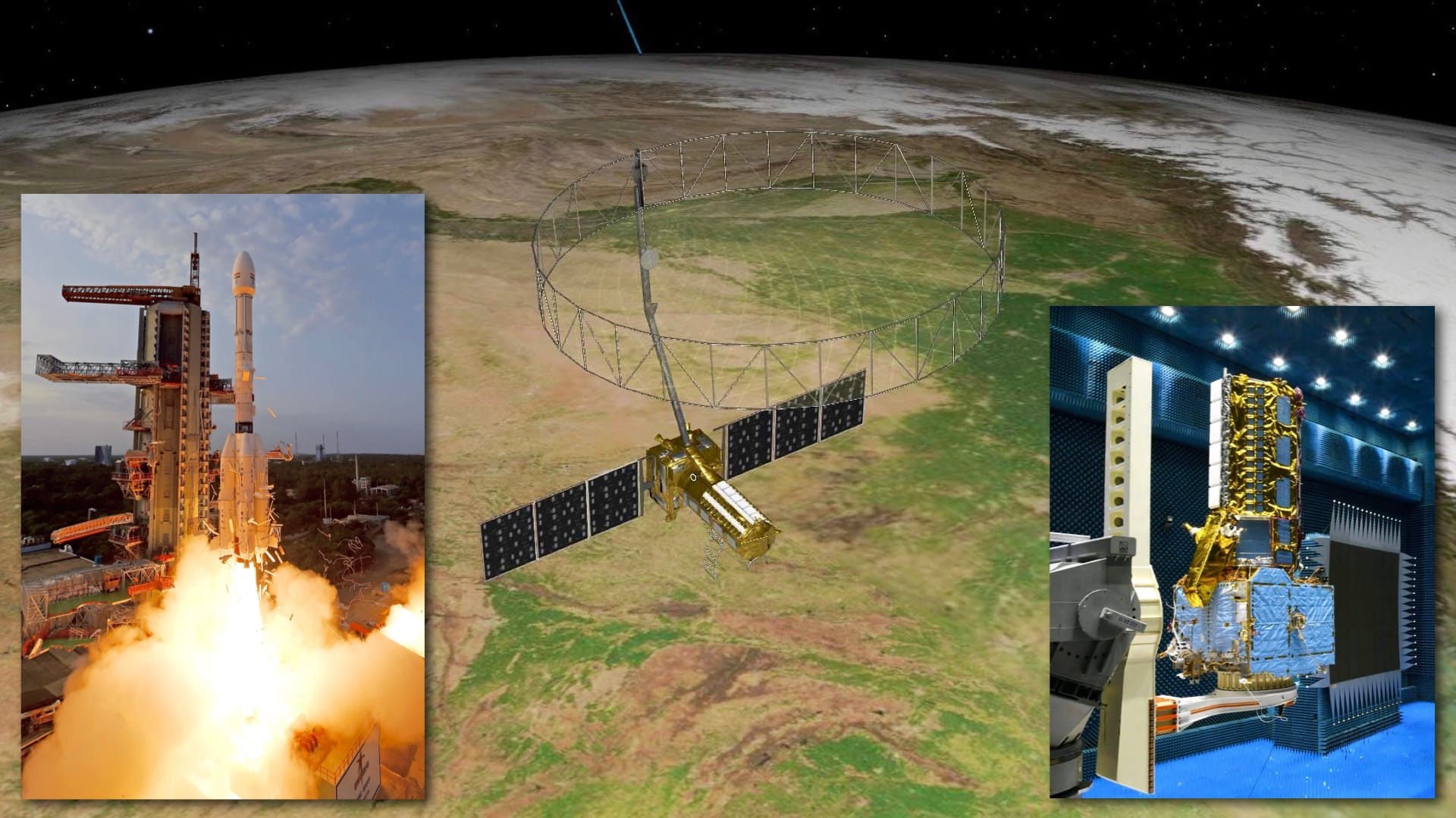
The July 30 launch of the NASA-ISRO Synthetic Aperture Radar (NISAR) spacecraft has put the first dual frequency radar system on a free-flying Earth observation satellite, with the longer wavelength L-band SAR coming from NASA and the complementary shorter S-band system from ISRO. Much has been covered about how over the next three years, these all-weather radar systems will repeatedly observe physical changes on Earth from a polar orbit at the finest scales while also touting the broadest, most time-consistent, and fully free global coverage so far. And so I won’t get into those same details in this article and instead let you look at some notable nuances about NISAR, and how it makes its way into planetary exploration as well.
At the heart of NISAR
Let’s start with the origin story of NISAR. Over a decade ago, NASA was formulating the L-band based DESDynI mission based on the US scientific community’s 2007 Decadal recommendation. ISRO’s S-band radar contribution to NISAR, which was formalized in 2014, came in to meet the specific goals of India. From the NISAR press kit:
In addition to using L-band data to meet the mission’s global science objectives, ISRO will leverage it to address a series of India’s Earth science priorities, including coastal wind velocity, seafloor topography near Indian coasts, the shape and position of the country’s coastlines, biomass measurements, geological features in the Himalayas and on the Deccan Plateau, and sea ice features in the Arctic and Antarctic.
Thus NISAR was born. These goals turned out to be complementary to ones NASA had while enhancing coverage and visibility for regions with extensive forest cover. If you probe deeper and look at the mission’s specific Level 1 (L1) requirements, you see two notable bits about how the mission objectives have been formalized:
The Level 1 Science Requirements define the specific science measurements that NISAR must perform to satisfy NASA's and most of ISRO's science goals. In addition to these joint requirements, ISRO has identified a number of additional Level 1 science requirements that are to be satisfied by the L-band radar instrument. These requirements then flow down to lower-level science and mission requirements that define the scope of the mission development and operations.
Two of these formal L1 requirements of ISRO are to specifically understand the nature of India’s landmass and its shorelines so to better plan agricultural and civilian development:
The NISAR mission will measure coastal wind velocity on a 1 km grid with an average sampling capability of 6 days, with an accuracy goal of 2 m/s over at least 80% of oceans within 200 km of India's coast.
The NISAR mission will image geological features over selected regions of India at 10 m resolution at an average sampling interval of 90 days with at least two viewing geometries. The regions include paleochannels in Rajasthan, linear features, and structural studies in the Himalayas and on the Deccan plateau.
To meet the whole set of L1 requirements and mission objectives, the finer requirements of L2, L3, and so on continue top down with increasing specificity of the engineering of the satellite and its subsystems. As such, NISAR’s ambitious scientific goals are ingrained into the very design of the satellite, and not something added up top as convenient. With its integral involvement in NISAR, ISRO is demonstrating a commendable commitment to understanding India’s natural ecosystems and their implications for responsible and more efficient national development. It harkens back to Vikram Sarabhai’s summary from 1969 of his efforts that decade to convince the Indian government to start a national space program in earnest:
There are some who question the relevance of space activities in a developing nation. To us, there is no ambiguity of purpose. We do not have the fantasy of competing with the economically advanced nations in the exploration of the moon or the planets or manned space-flight. But we are convinced that if we are to play a meaningful role nationally, and in the community of nations, we must be second to none in the application of advanced technologies to the real problems of man and society.
NISAR thus embodies the very spirit of using cutting-edge space technologies to solve humanity’s fundamental problems. The NISAR press kit highlights another such goal:
NISAR will study the planet’s ice-covered surfaces as they melt, move, and deform. The melting of the massive ice sheets covering Antarctica and Greenland has contributed about a third of global sea level rise, while the disintegration of mountain glaciers has added about the same share, in addition to affecting water supplies for billions of people. Meanwhile, the melting of polar sea ice can affect ocean circulation on a global scale.
NASA and ISRO have also baked in joint L1 requirements for NISAR, such as for the emergency observations the satellite will conduct post natural—or even human—disasters in any part of the world:
In support of responses to major natural or anthropogenic disasters, the mission system shall be capable of providing revised scheduling for new acquisitions within 36 hours of an event or an event forecast notification and delivering data within 9 hours of being collected, and shall exercise this capability on a best efforts basis.
Direct collaboration on NISAR extends beyond the two agencies, in fact. The specific SweepSAR radar mapping technique NISAR will use, which allows it to capture wide swaths of hundreds of kilometers without compromising on resolution, was developed and refined by NASA in collaboration with the German Aerospace Center (DLR). SAR company PierSight Space (a sponsor of Indian Space Progress) has noted in a blog post that Anthony Freeman, who led the NISAR program during its formulation phase, spearheaded the decision of NISAR to use SweepSAR. That’s because to meet NISAR’s objectives, having centimeter level of detail is as essential as gaining vast, global coverage.
NASA and ISRO have explicitly designed NISAR’s instrumentation such that both the L-band and S-band can work simultaneously as well where apt and necessary for achieving mission goals by combining the strengths of each:
The feed apertures at L- and S- band are built by JPL and ISRO, respectively, as well phase-matched to their respective electronics and cabling. In this sense, each radar is a self-contained instrument up to the radiated energy from the feed aperture. Thereafter, both will share the same reflector, with a nearly identical optical prescription (F/D=0.75). Because a distributed feed on a reflector-feed antenna has a single focus, much of the radiated and received energy is not at the focus. Since S-band wavelength is 2.5 times shorter than L-band, yet the feed is the same length to achieve identical swath coverage, the S-band system has greater deviations from the focus. Thus, the design has been iterated to derive the best offset, tilt and phasing of each radar to balance the performance across the two systems. This analysis has been done independently by the JPL and ISRO teams, then cross-compared to validate.
Like in a democracy, such a heavily integrated collaboration between different entities and their cultures is not easy to pull off and can certainly be time consuming. And yet the US Government Accountability Office (GAO) found in its 2018 assessment during NISAR’s development that the satellite was progressing despite risks stemming from procedural differences between the two agencies. In fact, the assessment noted effective collaboration thanks to NASA and ISRO having iteratively updated their cooperative project plan. Some GAO reports can be quite scathing, and so for NISAR to have had a favorable assessment is worth noting.
Many thanks to the Takshashila Institution, PierSight, GalaxEye and Gurbir Singh for sponsoring this month’s edition of Indian Space Progress. If you too appreciate my efforts to capture nuanced trajectories of India in space, support my independent writing.
Flowing into planetary science and back
The NASA-ISRO collaboration has since expanded to the Moon as well. Over the last few years, ISRO’s Chandrayaan 2 orbiter has been aiding NASA in selecting and filtering candidate landing sites for the crewed Artemis III Moon mission, which aims to put US astronauts back on the Moon later this decade.
This collaboration between researchers on both sides specifically involves the use of radar data from the ISRO orbiter’s Dual-Frequency SAR (DFSAR) instrument to uniquely characterize the Artemis III candidate landing zones. DFSAR has enabled NASA to sense valuable information on the physical state and structure of those regions, including mapping landing hazards for future landers to avoid. DFSAR has also been used to help reduce false positives where certain terrain on the Moon’s poles with rough textures seem like desirable water ice pockets but may not be.
And so, it’s interesting that while NISAR is the first free-flying Earth observation satellite to use dual-frequency SAR, we already did that at the Moon first through the Chandrayaan 2 orbiter DFSAR. For ISRO, its radar technology has first flown on Earth observation satellites, evolving later for use on Chandrayaan 2, and has now been fed back into NISAR. JPL’s various radar systems have recently flown on NASA’s planetary missions across the Solar System, honing a plethora of techniques over time. With NISAR, the two approaches have converged.
In an interview with The Hindu, NASA’s Director of its Earth Sciences division Karen Germain affirmed the cross-pollination of the agency’s radar systems across planetary and Earth observation missions, and went on to note how NISAR itself will also help scientists better understand other planets.
One of the things that NISAR is going to tell us about is what’s going on underneath the crust of the surface because we’ll be able to see these very small motions that you and I don’t experience daily, right? We can’t sense these. But NISAR will, and it will allow us to advance our models about how the interior of planets work.
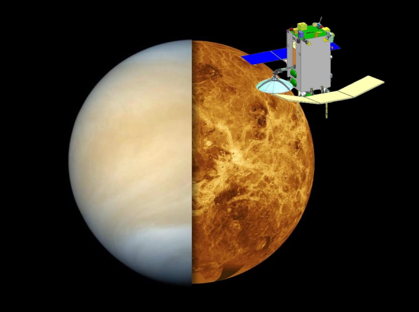
Venus comes to mind in particular. ISRO’s upcoming Shukrayaan Venus orbiter will fly the highest resolution radar to the searing planet thus far, taking cues from both the Chandrayaan 2 orbiter and NISAR. It will pierce through the planet’s thick clouds and sense the crust to help planetary scientists unlock long-standing Venusian mysteries, including the critical question of how Earth has remained so habitable while its sister planet turned into a hellscape. Moreover, NASA, ESA, and ISRO hope to coordinate and complement observations from their respective Venus missions and share data with each other to enhance the scientific output from them all. NISAR sets precedence for such multi-organizational scientific use as well.
When seen in this holistic context, NISAR is demonstrating peak peaceful uses of cutting-edge space technologies to not only solve humanity’s fundamental problems but also laying the path for helping us answer fundamental questions about our Solar System.
Read previous editions on Indian space
- Indian Space Progress #29: Was Shubhanshu Shukla’s Axiom-4 flight to the International Space Station worth it for ISRO?
- Indian Space Progress #28: A pressing PSLV rocket failure and orbital congestion to brood over
- Indian Space Progress #27: Three months of mission updates, and fixing ISRO’s monthly summaries