ISRO’s Chandrayaan 2 orbiter is creating the highest resolution map of the Moon
The spacecraft is quantifying just how much water ice exists on the Moon’s poles.
April 2025 update: The Chandrayaan 2 orbiter has helped produce a galore of lunar science results.
December 2021 update: Several research results have come out of the Chandrayaan 2 orbiter’s data since I wrote this article almost 2 years ago.
India’s space organization, ISRO, launched Chandrayaan 2 to the Moon last year in July. While its lander Vikram crashed on the lunar surface on September 7, the Chandrayaan 2 orbiter continues to orbit the Moon.
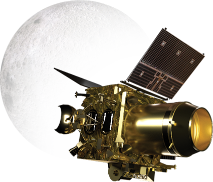
The Chandrayaan 2 orbiter hosts an extensive set of instruments to map the Moon and now we get a peek at the data it has sent.
ISRO scientists had submitted a raft of initial results from the orbiter’s mapping instruments to present at the flagship 51st Lunar and Planetary Science Conference in March. This is an annual conference hosted in the United States where more than 2000 planetary scientists and students from across the world attend and present their latest work. However, due to concerns about the new Coronavirus, the conference has been cancelled.
Seeing a crater in the dark
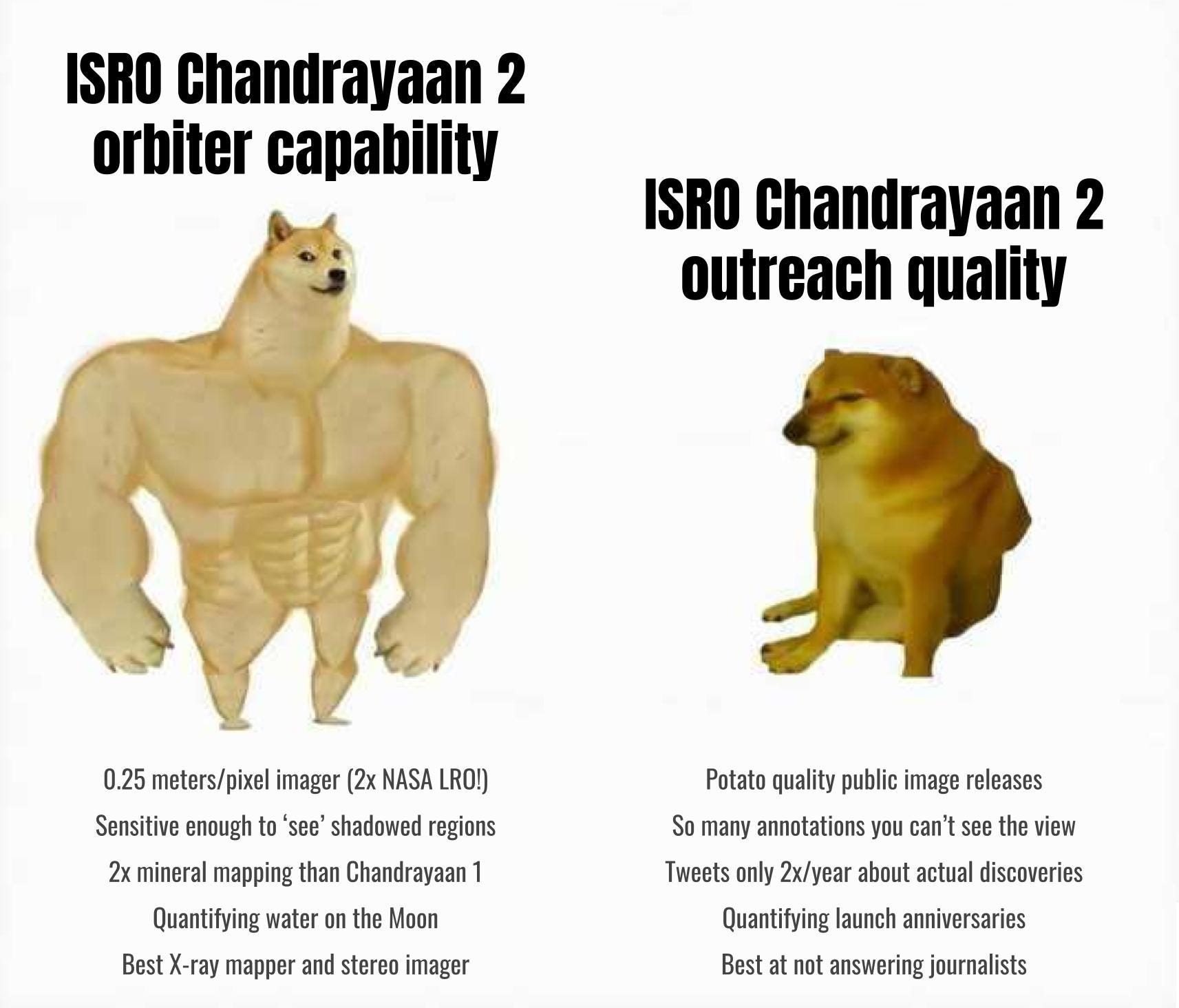
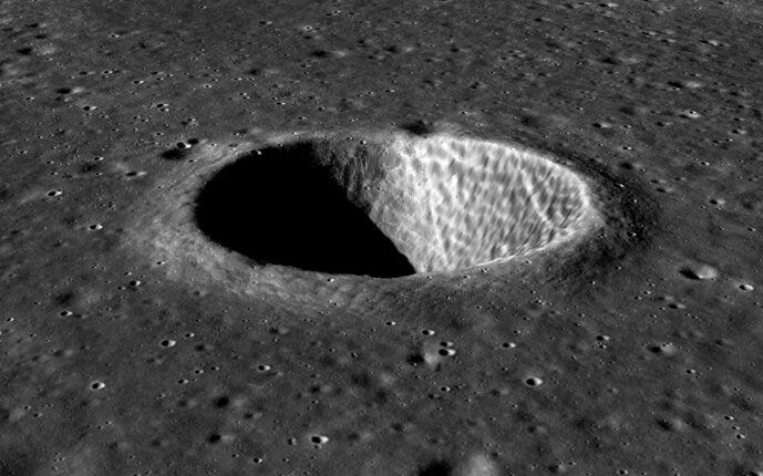
Chandrayaan 2 orbiter has an optical camera called the Orbiter High-Resolution Camera (OHRC) which captures detailed images of the Moon. OHRC can image at a best resolution of 0.25 meters/pixel, twice NASA Lunar Reconnaissance Orbiter’s (LRO) best of 0.5 meters/pixel.
Back in October, we already saw OHRC flex its muscles by sending images where boulders less than 1 meter in size were clearly visible. And now OHRC has demonstrated imaging an area not directly illuminated by sunlight! It captured an image of a crater floor in shadow by seeing the dim light falling on it that has been reflected from the crater rim!
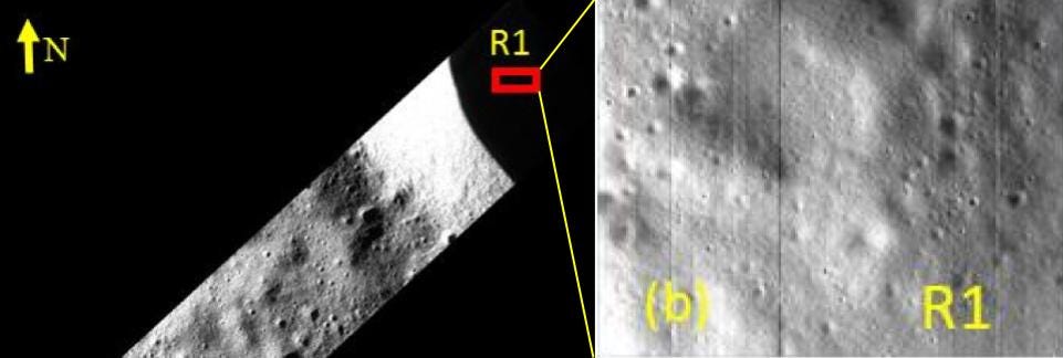
Moving ahead, this capability will be used to image insides of craters on the lunar poles, where sunlight never reaches. Mapping the terrain of polar craters is important because future lunar habitats are believed to be stationed near them, transporting water and other resources from inside them.
Highest resolution 3D maps
The Terrain Mapping Camera (TMC 2) onboard Chandrayaan 2 is a stereo imager, meaning it can capture 3D images. It does that by imaging the same site from three different angles, akin to NASA’s LRO, from which a 3D image is constructed.
TMC 2 has beamed back images taken from 100 km above the lunar surface and the 3D views generated from them look great. Here is one of a crater and a wrinkled ridge, the latter being a tectonic feature.
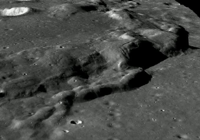
Such images are very useful for understanding how lunar features form and get their shape. For example, a 3D image can help construct an accurate picture of the geometry of the impact that formed a crater.
Over time, Chandrayaan 2 will provide the highest resolution 3D images of the entire Moon, the best case resolution being 5 meters/pixel.
Enhanced eyes in the infrared
The Imaging Infrared Spectrometer (IIRS) on Chandrayaan 2 is the successor to the famous Moon Mineralogical Mapper (M3) instrument onboard Chandrayaan 1.
The M3 instrument, which was contributed by NASA, has been publicly acknowledged for its excellent mineral mapping capabilities and detection of water on the Moon. Noah Petro, Project Scientist for LRO, recently noted on Twitter:
10 years ago today Chandrayaan-1 ended. I was so lucky to be a small part of that mission. The M3 instrument allowed us to take a huge step forward in learning about the composition of our 8th continent!
Both IIRS and M3 detect reflected sunlight from the Moon’s surface. Scientists identify minerals on the surface based on the patterns of these reflections. The IIRS boasts nearly twice the sensitivity of M3 in infrared light and the initial results demonstrate to that effect. Here are images of the Glauber crater as seen by IIRS and M3 respectively.
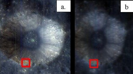
Thanks to M3, scientists now know that the lunar soil does hold trace amounts of water and hydroxyl molecules even in non-polar regions. IIRS onboard Chandrayaan 2 will map water concentrations in the lunar soil with improved sensitivity. Chandrayaan 2’s long-term observations aim to discern how the water content in the lunar soil changes in response to the lunar environment i.e. what the lunar water cycle looks like.
Note that all this is still less amount of water than the driest deserts on Earth. However, the lunar poles host appreciably more water. And that is where Chandrayaan 2’s radar comes into the picture.
Quantifying water on the Moon
The Dual Frequency Synthetic Aperture Radar (DFSAR) onboard the Chandrayaan 2 orbiter is the successor to the Miniature Synthetic Aperture Radar (Mini-SAR) on Chandrayaan 1. DFSAR penetrates the Moon’s surface twice as deep as Mini-SAR. Not just that, DFSAR also boasts a higher resolution than the radar onboard LRO called Mini-RF. The initial results demonstrate as much, comparing a DFSAR radar image of region with Mini-RF.
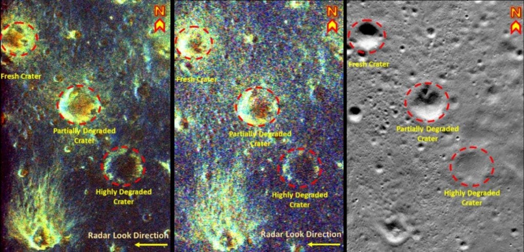
With greater penetration depth and higher resolution than any prior instruments, Chandrayaan 2’s orbiter is in the process of adequately quantifying just how much water ice is trapped inside the permanently dark regions on the Moon’s poles. Current estimates based on past observations suggest that the Moon’s poles host more than 600 billion kg of water ice, equivalent to at least 240,000 Olympic-sized swimming pools.
The Chandrayaan 2 orbiter also observes the Sun. Its high-resolution Solar X-ray Monitor (XSM) is used to study solar flares and provide a reference for the Chandrayaan-2 Large Area Soft X-ray Spectrometer (CLASS) instrument, which maps elements on the Moon’s surface.
What’s next?
The lunar science and exploration communities agree that we can harness water ice on the Moon’s poles to power future lunar habitats. Using solar power generated by the habitats, we can also split the water ice into hydrogen and oxygen for use as rocket fuel.
But before we plan habitats at the Moon’s poles, we need to know more about the nature of water ice in these regions and how to access it given their terrain. The initial results from Chandrayaan 2 clearly show the promise of the highest resolution mapper ever sent to the Moon. ISRO has stated that Chandrayaan 2 will orbit the Moon for seven years and that should be ample time to fully map and quantify water and their host regions on the Moon.
Surface missions that explore these water-hosting permanently shadowed regions, like NASA’s upcoming VIPER rover, are the next logical step towards sustainable habitats on the Moon. As we develop technologies that tap into water ice, we can settle on not just the Moon but the whole solar system. We should be glad our Moon has plenty of water; we can’t keep dragging everything out of Earth’s gravitational well forever.
Originally published at Universe Today, updated in 2022 with new results and additions.
Side note: The sheer opaqueness and lack of outreach ISRO demonstrates with its own missions is a pet peeve of mine. In fact, it’s partly why I write about Indian space in the first place. People across the world need to, and want to, know about the good and inspiring things India is doing with its civilian space program. Yet ISRO couldn’t seem to care less. To illustrate the stark difference in ISRO’s mission capabilities versus their outreach, I’ve created this meme.
